VIDEO: Heat Advisory goes into effect as temperatures hit the 90s

The hot weather pattern is back (it didn't go away for very long). Temperatures will once again top the mid 90s and low 100s for the rest of the week. Because of that, Heat Advisories have been issued for the majority of the Inland Northwest for Wednesday afternoon.
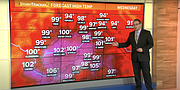
Temps will be around 92-102 degree Tuesday and about 95-102 for Wednesday. Even Thursday and Friday are looking hot too with highs in the mid to upper 90s.
The record high in Spokane for Wednesday, August 31 is 100° - which is also the latest 100-degree day on record. The record for Friday, September 2 is 97°.
For the most part it will be sunny and hot with the exception of Wednesday evening, where we have a very small shot at some isolated storms, but it's not looking good. With a lack of monsoonal moisture, these isolated storms will be much drier. The biggest threat will be lightning and locally gusty wind as the region continues to dry out in the August heat.
Speaking of, August is going to be one for the record books. Through the 29th, the average temperature in Spokane has been 75.8 degrees. That is almost 6 degrees above normal and beating the long-standing record warmest August, 75.2 degrees back in 1915. With even warmer weather in the days to come, it's likely August 2022 will be the hottest on record.
KREM2 News is a Hagadone News network partner. For more from our partners, visit www.krem.com.
Video
VIDEO: Hot end of August for Inland Northwest
Temperatures will be back in the upper 90s for the Inland Northwest as we wrap up a record hot August.