Crews battling area wildfires


Air support is helping firefighters as they battle a number of wildfires in the region, U.S. Forest Service officials said Tuesday.
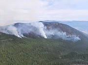
Helitack firefighters assigned to the Trout Fire but were unable to attack the wildfire due to an incoming weather system and current fuel loads, USFS officials said.
The Eneas Peak Fire, located about 15 miles north-northwest of Bonners Ferry, has burned 733 acres since it was reported Aug. 13. The Trout Fire, reported Sunday, has burned seven acres and is in an old burn scar, causing concern due to snags.
Air support was able to attack the fires with four fireboss helicopters, which are working both fires.
A Monday night infrared flight had better weather conditions, which provided a more accurate acreage of the fire, enabling crews to determine the fire isn't as large as previously mapped.
The Eneas Peak fire is holding on the eastern flank and is continuing a favorable move to the west, Forest Service officials said. Air support prioritized the northwestern part of the fire.
"Firefighter managers continue to strategize fire suppression tactics that include containing and confining," said Caroline Mcgough, Forest Service fire information officer, said. "Air support will be utilized as needed for both fires."
Tuesday's weather was expected to be much cooler with a chance of thunderstorms in the afternoon and a greater chance of showers on Wednesday.
Diamond Watch Fire
Located 5.5 miles due west of Nordman, the Diamond Watch Fire was mapped at 813 acres during an infrared flight on Monday. Most of the heat from the fire appears concentrated on the southern slope of a ridge to the east of Diamond Peak.
"Portions of the perimeter have not grown over the last week and fire officials are hoping to call those areas contained in the next few days, after the lines are tested by potential challenging winds from forecasted thunderstorms," Kary Maddox, Forest Service fire information officer, said. "Firefighter and public safety remain the top priority."
Firefighters are utilizing heavy equipment to help reinforce containment lines along the forest roads surrounding the fire.
"By clearing away the vegetation that parallels the roads it creates a large fuel break where firefighters can work from to safely fight the fire," Maddox said.
FSR 308 is being used as the southern and western containment lines and FSR 657 has been reinforced on the east connecting FSR 308 to Diamond Creek, which is acting as a natural barrier keeping the fire contained on the northern edge.
Forest Service officials said crews are reinforcing lines by digging additional handlines, laying hose, and setting up sprinkler systems to help stop any spread beyond containment lines.
"Direct action within the fire area would be very dangerous to firefighters due to the steep rugged terrain which is covered by dead and down trees in jackstraw piles," Maddox said.
Bear Gulch and Columbus fires
Located within a mile of the Idaho/Montana state line, the Bear Gulch Fire was sparked by lightning and confirmed on Aug. 18. Located in steep, rugged terrain, the fire is difficult to access, USFS officials said.
The fire has burned an estimated 40 acres.
Crews are currently working on helispot construction and gaining access to the fire, Maddox said.
"The firefighting strategy will be to monitor, confine, and contain," she added. "Crews will utilize natural features such as rockslides to help slow the fire's spread."
However, moderate activity is likely to occur as it transitions from northern to southern aspects until a season-ending event, officials said.
Likely a holdover from previous thunderstorms, the Columbus Fire was confirmed Monday. Located near the Idaho/Montana state line, the fire is near the Columbus Creek drainage in the headwaters of the East Fork of Eagle Creek.
Due to the area's rugged, steep terrain, access is difficult and fire managers are monitoring the fire and gathering information to decide a firefighting strategy. The fire has burned just over 8 acres.
Closures and evacuations
On the Diamond Watch Fire, closure orders are in effect for Forest Service roads 311, 308, and 1362H in the vicinity of the fire. However, FSR 1362 remains open. Petit Lake and is associated campsites are within the closure area.
On the Eneas Peak and Trout fires, residents are asked to avoid Trout Creek Road (Forest Service Road 634) as well as nearby trails to allow for fire suppression efforts in the vicinity. Trails included are Fisher Peak (No. 27), Pyramid Lake (No. 13), Pyramid Peak (No. 7), Trout Lake (No. 41) and Ball and Pyramid Lakes Trail (No 43).
On the Bear Gulch and Columbus fires, residents are asked to avoid Trail 148 along Casper Creek, Trail 7 from the intersection with Trail 774 to Thompson Pass, Trail 1107 near the state line, Trail 763 near the state line, Forest Service Road 938, FSR 430 and FSR 604CZ.
While there are no evacuations in place, when living in fire prone areas it is recommended that all area residents have an evacuation plan in place including having all important documents, pictures, prescriptions, and pets gathered up and easily transportable.
Residents of Boundary and Boundary counties can visit nixle.com or text their home's ZIP code to 888777 to sign up for emergency alerts