Ma Nature turning on the moisture

The weather pattern here in the Inland Northwest is changing to the wetter side as the storm door has finally opened up. Our first snow of December arrived on Friday with more expected over at least the next six weeks. Cliff and I see a good chance of at least moderate snows in the region around the Christmas holiday, so the odds of a white Christmas here in North Idaho are looking good.
Many were starting to wonder on whether we were going to get much snow this month. According to Cliff’s records, when we have the early snowfalls, especially in October, there is typically a break or an extended period of dryness, sometimes for up to six weeks, before we receive any additional snowfall. Despite November having slightly above-normal snowfall in Coeur d’Alene, the first 10 days of December 2020 were completely snowless. Since 1895, this is the 10th time without any measurable snow at this time of year in Coeur d’Alene.
For the latest extended forecast for Coeur d’Alene, we do have a 14-day weather outlook that is updated each day. It can be found on the Coeur d’Alene Press Facebook page at www.Facebook.com/CDAPress, or on the Press website at www.CDAPress.com. Forecasting that far in advance is not an exact science, but its purpose is to give a trend of what’s come down the meteorological roadway.
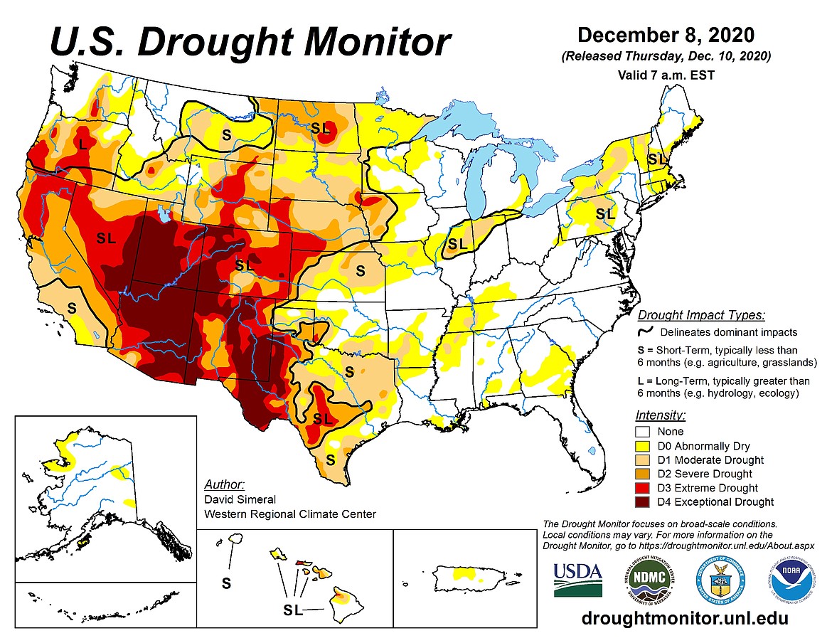
While it looks like moisture will be in good supply here in the Northwest over at least the next few months, the rest of the western half of the U.S. has been in the grips of a much drier-than-normal weather pattern as a very strong ridge of high pressure refuses to budge. According the U.S. Drought Monitor that is prepared by the U.S. Department of Agriculture, “severe to exceptional” drought conditions in the Far West have been expanding, especially in the last 3-4 weeks over the Desert Southwest. And, with the cooler-than-normal sea-surface temperature event, La Nina, below-normal rainfall is expected this winter season over much southern portions of Far West, which is not good news for much of California.
It’s been so dry in the Southwest that Phoenix, Ariz. did not see any measurable rainfall for 110 days. A storm last week did produce 0.46 inches of much-needed rainfall. According to an article from Accuweather, Phoenix has only had 15 days this year with measurable rain. The least number of days in a year when Phoenix has reported any moisture was 18. The longest dry stretch for that city was 160 days, which occurred in 1972.
Until last week, Yuma, Ariz., went 242 without rain and Bishop, Calif., has over 240 days without any measurable precipitation, and still counting. Accuweather also states that Las Vegas also had about 240 days without rain. Prior to this year, Las Vegas has never gone more than 150 consecutive days of dryness.
During the late spring and early summer months, the Desert Southwest, including Las Vegas and Phoenix, depend on monsoonal moisture from the Gulf of California and the Gulf of Mexico as the wind patterns usually reverse direction from dry land to the moist ocean. This year, moisture totals were below average resulting in widespread drought and high fire danger levels.
The water year across much of the West including California, Nevada and Colorado begins on Oct. 1 as the summer seasons are often rainless. According to the U.S. Department of Agriculture, the statewide snow water content for California is at 36 percent of the historical average through the first week of December. In the Mojave Desert, it’s the driest period on record as some areas are at 10 percent of normal rainfall.
Around the rest of the country, extreme drought conditions have migrated into Texas, especially the western portions. Most of the Great Plains are experiencing severe to extreme drought. The dryness has recently expanded eastward into Iowa, Illinois and Indiana. Parts of the northeastern U.S. are reporting dry to moderate drought levels. With the exception of pockets of abnormally dry areas, moisture totals in the Southeast to the Mid-Atlantic states are good levels.
However, the northern portions of the U.S. should start seeing some drought relief from this new pattern change. During a typical La Nina event, above normal rain and snow will often fall across the northern regions and the long-range computer models are beginning to show this new trend.