Tales from the Trail

<p>Cyclists can experience a bird's eye view of the Idaho National Forest from the trestles of the Hiawatha bike trail.</p>

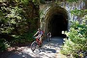
<p>Brad and Robin Haws, of Spokane, pass through a tunnel on the Route of the Hiawatha bike trial that was once a railroad.</p>
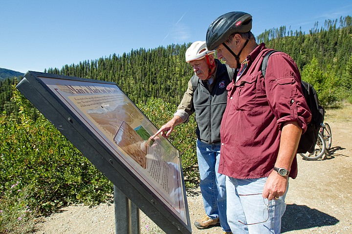
<p>Peter Luttropp, right, and George Evjen, both of Coeur d'Alene, read one of more than two dozen interpretive signs along the Route of the Hiawatha last Thursday during the duo's first trip on the trail.</p>

LOOKOUT PASS - There is a light at the end of the tunnel.
I can see it. Close enough to just run a few hundred yards and break out into the sunshine on the other side.
Well, maybe not.
As I peer through the darkness, Ric Clarke says the Taft Tunnel, also known as St. Paul Pass, which stands 23 feet high and 16 feet wide, is actually 1.7 miles long.
"Let's let our eyes adjust," he says as we switch on the flashlights attached to our bikes.
We wait in silence, and it is then I can hear the water dripping down and winding into the channels on each side of the cold, damp passage way blasted through a mountain.
"Try to stay in the middle," Clarke says as we begin pedaling our way into the mouth of this beast that leads us through the heart of the Bitterroot Mountains.
I follow instructions, since they come from the man who is the supervisor of the Route of the Hiawatha, which is operated by Lookout Pass Ski Area, about 60 miles east of Coeur d'Alene.
If you have issues with claustrophobia, I might not recommend this opening leg of our journey. There is a way around, well, over actually, on a forest road for those who don't care for being engulfed by sheer darkness.
"Most go through the tunnel rather than the forest road that goes over the top," Clarke says.
It doesn't take long.
Perhaps 15 minutes later, we emerge from the west portal and are greeted by bright blue skies, sunshine, and a waterfall and other bikers milling around.
"This is my new office," Clarke says with a laugh.
Amazing.
"We just crossed from Montana into Idaho, about halfway through the tunnel," he says, then offers a little more history on the project.
"When they built it, they had an Idaho team and a Montana team. It was a race to see who could get to the middle first," Clarke says with a chuckle. "The Idaho team won. They're all miners over here. They were about an inch off center when they met in 1909."
This trek on our bikes on a Thursday afternoon began at an elevation of 4,147. Over the next 13 miles or so, we'll drop nearly 1,000 feet on a downhill slope with a gentle 1.7 grade. Nothing too tough.
Before we're done, we'll pass through 9 tunnels, ride over 7 trestles and stop at several signs highlighting the area's history, like the Gandy Dancer's grave.
"There was one man who panicked during the 1910 fire and leaped off a rescue train," Clarke said. "The train continued onto Tunnel 20, and the rest of the passengers survived. After the fire passed, the other passengers buried him next to the tracks.
"He's assumed to have been a railroad laborer known as a Gandy Dancer."
The history is holding. The sights, superb.
This rail trail is a wondrous world where the Shefoot and Tanglefoot mountains loom close, and you're surrounded by an endless forest of towering lodgepoles, grand fir, red fire and tamaracks.
Clarke, who also oversees the Lookout ski school, notes the trestles offer spectacular views. Kelly Creek Trestle stands a mighty 850 feet long and 230 feet high, followed closely by Clear Creek Trestle, at 760 feet long and 220 feet high.
"It's amazing, looking down on the tops of the trees," Clarke says with a grin.
And those milemarkers you'll see, 1,751, 1,752, 1,753, as you coast along? Railroad miles from Chicago, Clarke explains.
"Or to Chicago, if you're headed east," he says.
This year, visitors have come from throughout the world to try the trail, where moose, deer and even bear sometimes roam.
"There was a moose one time who wouldn't give up the trail. Everyone just had to wait until it left," Clarke said.
July and August saw a record 23,584 guests on the mountain bike trail. That's up nearly 11 percent over last year's record season.
The Hiawatha is open through Sept. 26, closing a week earlier than usual due to various Forest Service projects in and around the trail, including an additional 139 parking spaces at the East Portal trailhead.
But perhaps the best is yet to come.
As the fall forces its way in, and summer settles aside, the colors turn to glorious golds and rich reds.
It's quiet, peaceful. Perfect.
"It gets prettier," Clarke says. "Mornings are crisp, it warms up mid-day. It's just gorgeous."
History
It was the late 1800s when Milwaukee Road, a railroad in Chicago, wanted to expand west. Part of that route from Chicago to Tacoma, Wash., would take it through the Bitterroot Mountains.
"Milwaukee wanted to get in on trade from the Orient, especially the silk end," Clarke says.
"They figured $60 million. It wound up costing them $260 million. It nearly bankrupted them," he says. "But it made them a lot of money ultimately."
Construction on the Pacific Extension started in 1906 and would take until 1911. Along the way, it created thousands of jobs. Towns like Roland and Adair sprang up. Not even the 1910 fire could stop it, though it tried.
"This is one of those earth-filled trestles," Clarke says. "It's covered with dirt. The reason the railroad did that, they had just finished this in 1909, then the 1910 fire came through and burned all their wooden trestles. So they covered them with dirt so that would never happen again."
The name Route of the Hiawatha can be traced back to the Olympian Hiawatha, a steam-operated passenger train that could travel 100 mph and ran from Chicago to Seattle.
The train was named after Chief Hiawatha, who, according to legend, could run like the wind - even faster.
"He could run so fast, he could shoot an arrow, run ahead of it and catch it," Clarke said. "They wanted to give the impression this train was fast."
But perhaps not fast enough.
The money ran out and in 1977, Milwaukee Road went bankrupt. The last train passed through in 1980 and the line was soon abandoned.
The rails were eventually removed, and with government funding and private donations, construction of a bicycle and hiking trail began in 1997. The Idaho portion opened in 1999. The Taft Tunnel opened in 2001.
Quite a ride
Today, the route of the Hiawatha is a stunning stretch that opens in late May and operates into early October.
The ease of the sloped journey unites young and old.
"We've had kids with training wheels," Clarke says. "That's what is nice about it. Families can do it together."
Those using the trail can rent bikes or bring their own. Helmets and flashlights are necessary. Durable mountain bikes are $30 to rent from the Lookout bike shop, and include helmet and light.
Trips can take five or six hours if you bring lunch and stop to read the interpretative signs and take pictures. Or, you can roar down in an hour and a half.
"Kids tend to race down and not look at anything. Older people take it easy and take in the scenery," Clarke says.
Be sure to bring water, as there are no refreshments on the trail.
After reaching the end of the trail, most riders take the shuttle back up to Roland, a town during construction of the tunnel, where they can then bike back through the Taft Tunnel to reach their car.
Some choose to ride back up the trail.
Trail passes are $9 for adults, $6 for kids. The shuttle costs the same, $9 for adults, $6 for kids. Season passes for the trail are $25.
None complain about the price.
Coeur d'Alene residents and friends George Evjen and Pete Luttropp took the trip on the Hiawatha for the first time last week.
The two tried the Pulaski Tunnel Trail a few weeks ago and decided it was time to visit the Hiawatha.
"I think the closer you are to something, the less likely you are to see it," Luttropp said.
And now that they've see it?
"It's gorgeous," Evjen said. "You can't beat the mountains."
And certainly, you can't beat this ride.