

No hurricanes thus far in the Atlantic and Carribean waters

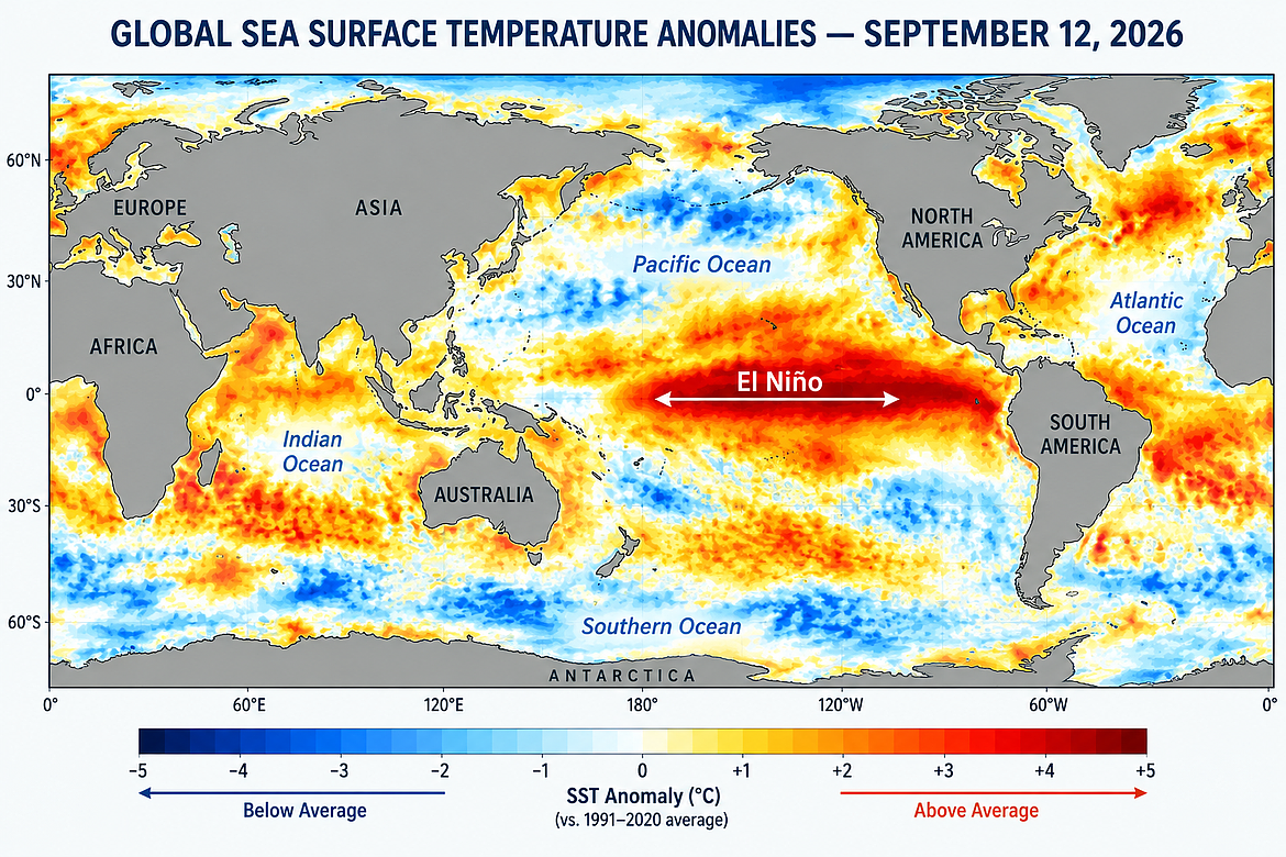
As I’ve mentioned in previous articles, we currently have a warmer than normal sea-surface temperature event, El Nino, in the south-central Pacific Ocean. According to the latest U.S. Climate Prediction Center outlook and discussion, ocean waters are above average levels across the east-central and eastern Pacific Ocean.
Atmospheric circulations are also consistent with the new El Nino and the latest forecasts continue to say that the chances of a very strong event during the fall and upcoming winter months are very high, over 90%.
The latest El Nino event did form much faster than most previous ones. Through early February 2026, sea-surface temperatures along the equatorial Pacific were below average and consistent with the cooler La Nina. However, starting in the middle of April 2026, ocean waters started warming across the eastern Pacific Ocean. The latest data indicates that readings in this region have climbed nearly 5 degrees Fahrenheit since last May.
As we head toward the end of 2026, this is shaping up to be a major El Nino, perhaps the strongest and potentially comparable in magnitude to events such as 1982–83, 1997–98, and 2015–16. It is still too early to say that it will exceed those events, but NOAA’s current probabilities make this a very significant climate event as it continues to strengthen rapidly.
During an El Niño, there is often a weaker Atlantic hurricane season because the warm water phenomenon increases vertical wind shear over the Atlantic Ocean. Wind shear is the change in wind speed or direction with height as hurricanes require calm upper-level winds to grow. Strong wind shear will usually tear storms apart before they can strengthen.
We have already passed the early September normal peak of the tropical storm and hurricane season in the Atlantic and Caribbean regions. For 2026, there have been only 5 named storms with none of them becoming hurricanes.
Based on the 30-year average from 1991 to 2020, the number of named storms is 14 with seven of them becoming hurricanes. There is also an average of 3 major hurricanes. The Atlantic tropical storm and hurricane season officially began June 1 and will continue through November 30.
Despite the current below normal named tropical storms, the ones that did form did impact the Gulf region this year. According to the latest data, there has been over $1 billion in total damage from these systems.
While El Nino often leads to less named storms in the Atlantic and Caribbean waters, the change in atmospheric circulation usually produces more named storms in the eastern Pacific. The season in this region begins May 15 and there have been 16 named storms, six hurricanes and four major hurricanes of a Category 3 or higher. The seasonal average in the eastern Pacific Ocean is about 15 named storms with eight hurricanes and four major hurricanes.
The most recent hurricane was Hurricane Lowell that affected Hawaii earlier this month. The storm did reach a Category 5 status but did weaken to a Category 2 when it passed near Hawaii. Kauai was the island most impacted as Lowell knocked down trees and power lines that left thousands without electricity. Heavy rains also led to flash flooding as damage was the most significant in this region since Hurricane Iniki in 1992.
Based on long-term averages, El Nino events tend to last approximately 9-12 months and recur about every 2-7 years. However, long-term forecasts are beginning to indicate that El Nino could start weakening in the spring of 2027. There is also the possibility of a new cooler La Nina forming around the middle to the end of next year. It’s too soon to tell, but in this era of wide weather “extremes,” it’s certainly possible that sea-surface temperatures could flip from the very warm to the cooler side in a short period of time.
In terms of our local weather, despite the much-needed recent rainfall, the latest U.S. Drought Monitor still has most of our region in severe drought. However, the rainfall this weekend will likely ease the situation across the Inland Northwest.
The normal precipitation for Coeur d’Alene in September is 1.48 inches and thanks to the record rainfall earlier in the month, many locations are reporting over 2 inches for September. As of Sunday afternoon, Cliff Harris was reporting 2.20 inches in Coeur d’Alene. With the new rapidly strengthening El Nino, it’s not likely we’ll have a good season for snowfall, especially in the lower elevations for the 2026-27 season. But, with this wild cycle of “extremes,” we may have a few winter surprises. Stay tuned.
• • •
Contact Randy Mann at [email protected].
 Current El Nino