

El Nino continues to strengthen

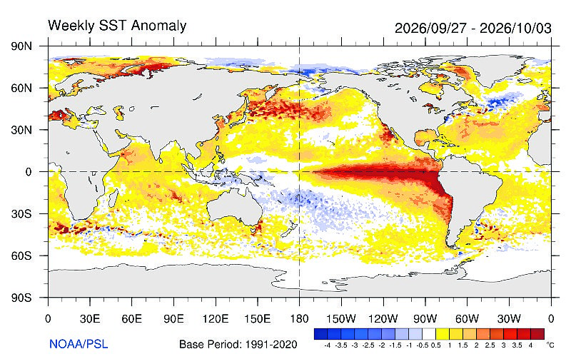
For many months, we have been featuring the strengthening El Nino in the waters of the south-central Pacific Ocean. According to the World Meteorological Organization and other major forecasters, ocean waters in this region, and especially along the Equator, are expected to increase to above record levels over the next several months.
As of early October, ocean waters near the West Coast of South America and along the Equator are approximately 4 degrees Fahrenheit above long-term averages. The El Nino is forecast to peak in December, but the latest computer models forecasts are suggesting that sea-surface temperatures could climb to as high as 6.7 degrees Fahrenheit above normal levels in the coming months. The previous record was about 4.68 degrees Fahrenheit above normal from the 2015-16 event and the one in 1982-83.
Once El Nino’s expected peak in December, it is very likely that it will persist through at least February 2027 and potentially be one of the strongest since 1950. Some of the forecast models are also suggesting that sea-surface temperatures may cool down in the middle of 2027 to a level where a new cooler La Nina is declared late next year. Talk about extremes.
As I’ve mentioned in previous articles, a strong El Nino will often lead to less named storms in the Atlantic and Caribbean waters. By contrast, the central and eastern Pacific Ocean will often experience higher than average named storms. For 2026, this has been the trend. However, a strong El Nino does not guarantee that a major hurricane will form in the Atlantic or Caribbean.
In fact, the season’s first hurricane, Isaias, formed in the Gulf of America (Mexico) last week and made landfall near Denton, Fla., on Friday evening as a Category 2. Isaias did strengthen to a major Category 3 before weakening as it moved into the Southeast. Power outages in Florida, Georgia and Alabama were approximately 900,000 customers.
Prior to the formation of Isaias, there were eight tropical storms that formed in the Atlantic and Caribbean. Despite the season being “quieter than normal,” total damage from those systems totalled to over 1 billion dollars. That figure will likely climb significantly with the effects of Isaias.
One of the most consistent impacts of a strong El Niño in the U.S. is a shift in the upper-level jet stream. The subtropical jet stream tends to strengthen and move northward, bringing increased storm activity across the southern tier of the country, including California, Texas, and regions along the Gulf Coast. This can be beneficial in drought-stricken areas, particularly in California, where increased rainfall and snowfall in the Sierra Nevada help replenish reservoirs and snowpack. However, excessive precipitation can also lead to flooding, landslides, and infrastructure damage, especially when storms are intense or prolonged.
In the active Pacific Ocean, where there has been 21 named storms and 11 hurricanes, Tropical Storm Rachel made landfall across Baja California last Saturday night. The storm is forecast to head to the northeast and bring moderate to heavy rain to Southern California and across the Desert Southwest. It’s very likely that “flash flooding” will be seen across this part of the country early in the week as 1-3 inches of rain is possible across portions of the interior Southwest. The remnants of Rachel did produce several feet of snow in the mountains of Montana.
Across the Inland Northwest, the super-strong El Nino is expected to bring above normal temperatures to the area for the rest of the fall and at least the early winter season. While the overall period is likely to be warmer than normal, there should be some occasional cold spells as Arctic air moves southward. In the coming weeks, Cliff Harris and I will have our annual detailed snowfall forecast for the Inland Northwest.
The chances of icy weather do increase during an El Nino event. For example, a severe ice storm in the Willamette Valley in January 2024 knocked out power to hundreds of thousands of residents across Oregon and Washington. During the last big El Nino event in December 2015 into January 2016, there were nearly a dozen winter storm and ice events in Oregon with about seven in Washington. Of course, the “Great Ice Storm of 1996” hit the North Idaho Panhandle and surrounding regions during a strong El Nino event. The storm resulted in severe ice jams and historic flooding across the Coeur d’Alene and St. Joe River basins.
In terms of our local weather, since the big rains in early to mid September, only 0.11 inches of moisture has fallen at Cliff Harris’s station in Coeur d’Alene. Since Jan. 1, 2026, approximately 11.30 inches has fallen in Coeur d’Alene, well below the normal of about 18.30 inches.
• • •
Contact Randy Mann at [email protected].
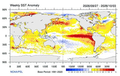 Weekly SST anomality