

Crews gain ground on area fires
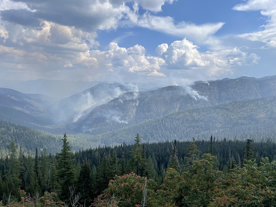
A view of the Spruce and Spruce Ridge fires about mid-day on Monday, Sept. 8.
Photo courtesy USDA FOREST SERVICE
SANDPOINT — Cooler temperatures and increased humidity helped crews gain a handle on the Sage Brush Fire.
Reported early Monday afternoon, the fire briefly forced the evacuation of residents along several roads in the Athol area and prompted others to prepare as a precaution. The evacuation advisory was downgraded Monday evening, with residents on roads near the fire — located 3 miles north of Athol — placed on “Ready” status instead.
Under the Ready-Set-Go evacuation protocols, “Ready” means residents should have an evacuation plan in place. If conditions worsen, they move to “Set” status, which means they should begin implementing that plan. If the situation becomes critical, “Go” status is issued, meaning residents must evacuate immediately and head to safety.
The fire has burned roughly 47 acres and is 30% contained. About 100 personnel are assigned to the fire.
Crews remained at the scene overnight and resumed firefighting operations Tuesday morning. Resources include four hand crews, eight engines, two dozers and one tender.
Idaho Department of Lands officials reminded residents to avoid areas where crews are working.
“The area is surrounded by private property, and several owners have opened private gates and roads to allow suppression crews to move around freely,” officials said. “As a result, personnel are reporting increased activity from recreational off-road vehicles, which can impact firefighter safety and hamper efforts. Please give them a safe space to work and respect private property rights.”
Ulm Creek Fire
The Ulm Creek Fire, located 16 miles north of Prichard on the Coeur d’Alene Ranger District, is 10% contained.
It has burned an estimated 2,713 acres, with 202 personnel assigned, including three engine crews, three hand crews, six water tenders, assorted heavy equipment units and three fire suppression modules.
The fire saw minimal growth. The acreage estimate is based on ground observations. Most activity is occurring on the northern flank, but officials noted that “fire behavior was still minimal.”
Crews continue reinforcing containment lines along Forest Roads 412 and 992, and creating defensible space around Gem Peak Lookout and Gem Peak Warming Hut. Skidders are being used to move materials near the structures to the landing piles.
Fire behavior through Monday was minimal, with some smoldering observed. Rain and thunderstorms are expected over the next week, with wind gusts of 30 mph during storms.
“As unstable weather moves into the area, moderate fire behavior is expected,” officials said.
Green Rattle Complex
On the Green Rattle Complex — which includes the Green Mountain, Rattle Mountain, Spruce and Spruce Ridge fires — 84 personnel are battling the complex fire located on the Sandpoint Ranger District. A complex fire refers to two or more wildfires that have either merged or are being managed under a single incident command.
The fires have burned an estimated 367 acres since being sparked by lightning between Aug. 29 and Sept. 2. They are 0% contained, with 160 personnel assigned.
Of the fires, the Green Mountain Fire has burned an estimated 13 acres, the Rattle Mountain Fire has burned 102 acres, the Spruce Fire has burned 201 acres and the Spruce Ridge Fire has burned 51 acres. Each has grown slightly over the past few days, with the most activity being seen on the Spruce Fire, U.S. Forest Service officials said.
“Crews are working diligently to keep the fires contained within National Forest boundaries,” officials said.
The Green Mountain Fire is 8 miles west of Clark Fork, the Rattle Mountain Fire is 13 miles north-northeast of Clark Fork, the Spruce Mountain Fire is 12 miles southwest of Troy, Mont., and the Spruce Ridge Fire is 13 miles southwest of Troy.
Structure protection efforts were completed Monday near the Green Mountain Fire, focusing on private properties. Critical structures include the Keeler Warming Hut, the Bear Mountain SNOTEL site and important cultural and natural resources.
USFS officials said crews made progress strengthening control lines using existing roads and trails. Although no evacuations are currently in place, the public is urged to stay clear of the area to support firefighting operations.
The Green Mountain Fire, detected after an Aug. 29 lightning storm, is burning in steep, cliffy terrain above Lake Pend Oreille, commonly known as the Green Monarchs.
Lightning Creek Fire
The Lightning Creek Fire remains 25% contained. Located 9 miles north of Clark Fork, 109 personnel are assigned to the 2,515-acre fire.
Roads and trails surrounding the fire are closed for firefighter and public safety. A temporary flight restriction is also in effect.
Smoke and haze will continue to moderate fire behavior across all incidents, officials said. However, afternoon thunderstorms and associated winds could increase fire activity.
“These storms may produce erratic winds, which could impact fire behavior and suppression efforts,” officials said in an update. “Despite the incoming moisture, fuel conditions remain extremely dry, maintaining elevated fire risk.”