

Tale of two water supplies
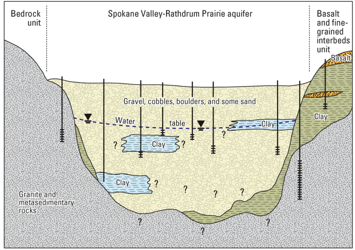
A depiction of the Spokane Valley-Rathdrum Prairie Aquifer in the Spokane Valley-Rathdrum Prairie Aquifer Atlas.
Courtesy photo
With groundwater in parts of Eastern Washington declining at an alarming rate, a new study confirms which areas are most vulnerable to the problem and could help set clearer goals for recovery efforts.
The Washington State University study evaluated groundwater levels throughout the Washington portion of the Columbia Plateau Regional Aquifer System, which spans areas of Washington, Oregon and Idaho, and supplies up to a third of the region’s irrigation water.
Researchers found that the Odessa region and the Yakima Basin in Eastern Washington are seeing groundwater levels drop by at least 2 to 3 feet per year. The declines in those areas are primarily attributed to a combination of groundwater overuse and climate variability.
“This gives a quantitative target of how much water needs to be either put back into the ground or needs to be managed around to bring us back to some sort of steady condition,” said Sasha McLarty, study author and associate professor of civil and environmental engineering at Washington State University
The Washington State Department of Ecology estimates that groundwater supplies drinking water to over 60% of Washington residents.
Odessa region shows most significant groundwater level decrease
Most municipalities have groundwater wells, and rural residents typically have wells on their properties, according to Jaime Short, section manager for the department’s Eastern Regional Office.
In Eastern Washington, Short said, groundwater is primarily used for irrigated agriculture.
The Odessa region showed the most significant groundwater level decreases over the largest geographic area in Washington. The study notes that groundwater is the main water supply for the Odessa area.
If groundwater levels continue to decrease at their current rate, the Odessa region will likely lose 10% of accessible groundwater by 2040 and 50% within the next 70 years, according to the study.
The Yakima Basin showed steep declines in the deepest aquifer layer, making it more difficult to address the groundwater loss, McLarty said.
The study confirms what the Department of Ecology and local stakeholders have known for decades, said Department of Ecology hydrogeologist Chris Beard.
“Where it’s declining, it’s been declining for a long time,” Beard said.
Impacts of drought on the Spokane Valley-Rathdrum Prairie Aquifer
Kootenai County is currently experiencing a mixture of severe and extreme drought, according to the U.S. Drought Monitor.
Meg Wolf, a hydrologist from the Idaho Water Resources Research Institute, said drought reduces the recharging of the Spokane Valley-Rathdrum Prairie Aquifer.
"It's been very dry this summer, very hot, but we did have a wet winter, so the average between that wet winter and dry summer is still kind of OK on the drought monitor, but if you look on the drought monitor for the last 100 years, the aquifer responds to what is coming into it and what’s being pulled out of it," Wolf said.
Wolf noted that spring runoff from the winter snowpack has trended earlier and earlier in recent years. Runoff used to occur in May, but is now happening about 30 days earlier in April.
If everything shifts a little earlier, it further reduces groundwater recharging, Wolf cautioned.
"One of the questions we have at the University of Idaho and statewide is, 'How will changes in the future that impact snow impact how much water is getting into the aquifer and at what time that’s happening?'" Wolf said.
The Spokane Valley-Rathdrum Prairie Aquifer lies within four counties: Kootenai, Bonner, Stevens and Spokane in Idaho and Washington.
The aquifer is the source of almost all drinking water for the Spokane and Coeur d’Alene regions and in Kootenai County alone, more than 2,200 wells tap into the aquifer.
"Hayden Lake is a good example. It’s a mountain watershed. The lake itself doesn’t have an outflow; it just goes straight into the aquifer," Wolf said. "That all takes time for water that starts in the mountains to get into the lake, the lake is kind of a holding reservoir and then it gets into the aquifer."
When there are warm, dry conditions during drought, there is an increase in evaporation and transpiration. More water is put back into the atmosphere, reducing the water available during recharge of the aquifer.
According to the Spokane Valley-Rathdrum Prairie Aquifer Atlas, the aquifer encompasses 370 square miles, with much of it located beneath Kootenai County and flows underground into Washington, discharging into the Spokane River.
When it comes to short-term and long-term drought, Wolf said there’s not a direct recharge of the aquifer and a lot of that water reevaporates into the atmosphere.
"Our aquifer is doing all right, with the caveat that we don’t know what the future holds," Wolf said.
The U.S. Environmental Protection Agency designated the Spokane Valley-Rathdrum Prairie Aquifer as a sole source aquifer in 1978.
A sole-source aquifer is one that supplies at least 50% of the drinking water in the area overlying the aquifer and has no alternative drinking water source that could physically, legally and economically supply all those who depend on the aquifer for drinking water.
Positive groundwater trends in areas of Spokane, the Lower Snake River and Klickitat
Of the 15 subareas in Washington included in the study, 12 showed groundwater levels dropping every year, while three — Spokane, the Lower Snake River and Klickitat — were found to be gaining water.
The positive trends in those areas are primarily due to active management and monitoring efforts, according to McLarty.
While communities that know they’re losing groundwater have taken action to mitigate that loss, there are significant gaps in groundwater level data around the state.
“Our groundwater data measurements are actually pretty clustered in certain areas, so there are large parts of the state where we simply don’t have data,” Short said.
Most of those data gaps are in areas that are not heavily populated, according to Short.
Filling in those data gaps so researchers can track groundwater trends statewide over time is a goal for the Department of Ecology, Short said. The Washington State University study was part of the ongoing effort to do so.
It emerged from a legislatively mandated project established in 2006, which calls for an estimate of current and future water supply and demand to be collected every five years.
This year’s study was the first to incorporate an observation-based analysis across the whole Columbia Basin Aquifer, McLarty said.
That strategy allowed researchers to document trends in different geographic areas of Washington, as well as trends within different layers of the aquifer, to better pinpoint where water is available and where it’s declining.
The study was also the first to take well infrastructure into account when determining what areas are vulnerable to groundwater loss.
• • •
Contributing reporting by Carolyn Bostick/CDA Press
Washington State Standard, like the Idaho Capital Sun, is part of States Newsroom, a nonprofit news network supported by grants and a coalition of donors as a 501c(3) public charity.