La Niña may spell wetter winter for North Idaho
North Idaho is currently receiving a dose of La Niña weather, something that could mean more precipitation than usual this winter if the trend continues.
A weak La Niña system is at work, according to the federal Climate Prediction Center, which has released a three-month outlook for December, January and February in association with the National Oceanic and Atmospheric Administration.
Meteorologist Jeremy Wolf of the National Weather Service based in Spokane said the outlook currently favors the La Niña advisory for the region.
“Typically, more snow occurs than normal in a La Niña winter. La Niña is already occurring, and it’s forecast to continue through the fall with a 55% chance it continues through the winter,” Wolf said.
The outlook was issued Oct. 16 and indicates a 33% to 40% chance of colder temperatures for North Idaho. The center is calling for above-normal precipitation for many areas of Idaho, and higher near Montana.
“There's still a fair amount of uncertainty how this winter will play out,” Wolf cautioned. “Typically, with La Niña winters, the odds are tilted toward cooler and wetter than normal conditions for North Idaho.”
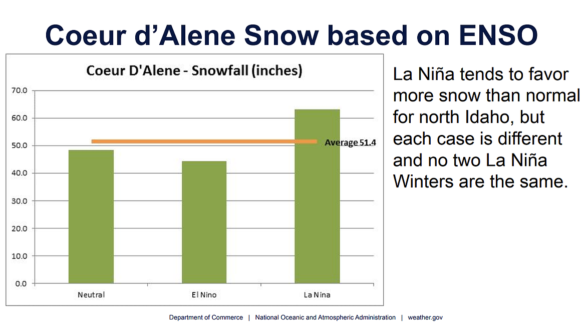
Coeur d’Alene receives about 51 inches of precipitation as an average of recorded winters.
“For the past several years when we look back at the previous La Niñas, on average, there's about 63 inches that falls in the Coeur d’Alene area,” Wolf said.
Unlike La Niña events, snowfall in the past has trended toward lower totals during El Niño weather events.
Winter officially begins with the winter solstice Dec. 21 and runs through the spring equinox March 19.
The Old Farmer’s Almanac is predicting a “mild winter with mixed precipitation and fluctuating snow amounts” in the Intermountain region, which includes Idaho, according to a report in the Idaho Statesman.
Temperatures are expected to be above normal in Idaho, with the coldest periods in late November, early December and early February in that region, the almanac said.