

Look to the skies
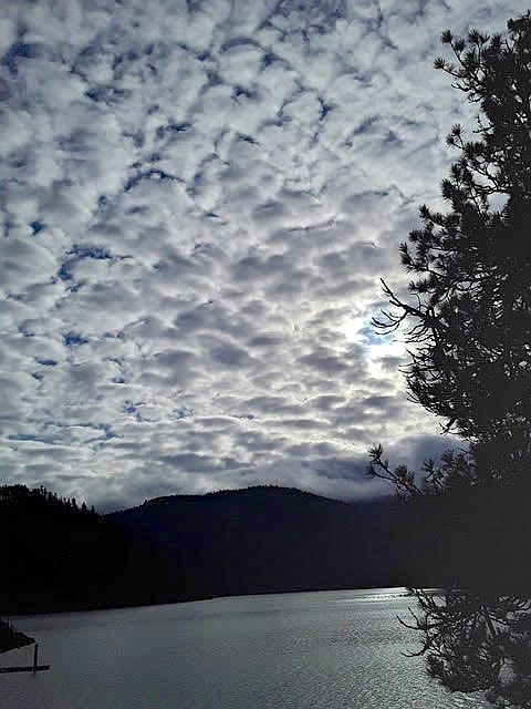
A cloud pattern is seen Dec. 8 over Lake Coeur d'Alene. Stratus, altocumulus, altostratus, cirrus and cumulus clouds are many times responsible for various cloud formations in North Idaho skies.
Photo by BARB ZIMMER
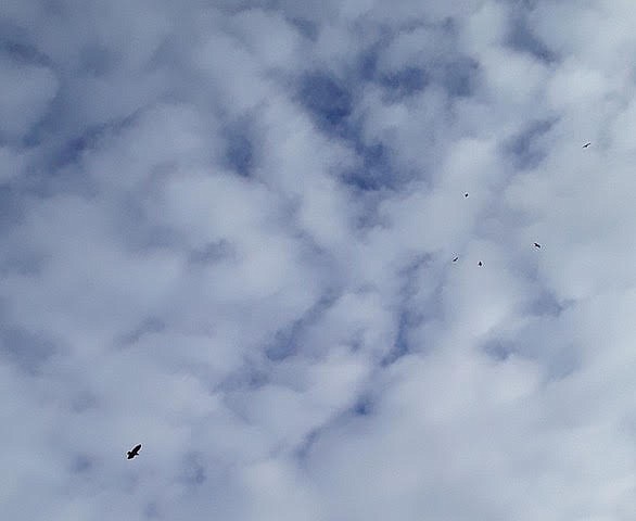
Coeur d'Alene Resident Barb Zimmer snapped this photo of a unique cloud pattern over Lake Coeur d'Alene while out watching bald eagles Dec. 8.
Photo by BARB ZIMMER
On certain days, during particular meteorological and atmospheric conditions, one only needs to look up to witness something special.
Winter skies over North Idaho can produce breathtaking patterns and eye-catching displays of towering, dappled or geometrical clouds. Low stratus clouds are often responsible for these pillowy presentations, as well as also mid-level cumulus and altostratus clouds and the higher-up cirrus and cumulus clouds, according to meteorologist Randy Mann.
"Clouds form when the invisible water vapor in the air condenses into visible water droplets or ice crystals," Mann told The Press via email. "For this to happen, the parcel of air must be saturated, i.e. unable to hold all the water it contains in vapor form, so it starts to condense into a liquid or solid form."
Stratus clouds are generally seen as a gray cloud layer with a uniform base which, if thick enough, may produce light rain, ice prisms or snow grains, according to the National Oceanic Atmospheric Agency.
Blue sky is often seen when a stratus layer breaks up and dissipates. These clouds can appear as ragged sheets. They do not produce a halo phenomenon except at extremely low temperatures.
Altostratus clouds are gray or bluish sheets of cloud cover that may partially or fully cover the sky. They're thin enough to allow the sun to appear as it would through ground glass.
"Sometimes virga (streaks of rain) is seen hanging from altostratus and at times may even reach the ground, causing very light precipitation," the National Oceanic Atmospheric Agency explains.
Composed of ice crystals, cirrus clouds are wispy formations that appear in patches or bands. They are often bright yellow or red as the sun rises or sets, and they tend to be lit up long before other clouds and fade out much later, turning gray after sunset.
Cumulus are fluffy, dense clouds that can resemble cauliflower. They are seen over land on clear days and tend to dissipate toward evening. Cumulus clouds typically form in the warmer months.
"Heat from the ground will also contribute to the rising of air," Mann said.
Some of the more rare and eye-catching clouds over North Idaho are cumulonimbus that are strong enough to produce very severe weather, but they're generally not cold weather clouds.
"We do see these in the spring and summer," Mann said. "When they produce a 'wall cloud,' that’s when tornadoes are produced, but mainly east of the Rockies."
Coeur d'Alene resident Barb Zimmer shared photos with The Press of cloud displays captured Dec. 8 over Lake Coeur d'Alene.
"We were out watching eagles ... and stood under these marvelous clouds," she said.
Mann said more clouds and storms occur in the mountains due to orographic lift. According to the National Oceanic Atmospheric Agency, orographic lifting takes place when air is forced to rise and cool due to topographical features such as hills or mountains.
"If the cooling is sufficient, water vapor condenses into clouds," the National Weather Service explains at forecast.weather.gov. "Additional cooling results in rain or snow. It can cause extensive cloudiness and increased amounts of precipitation in higher terrain."
Different conditions can produce a variety of cloud formations, such as in the photos Zimmer shared. One rare phenomenon is known as a cloud hole or "fallstreak," which looks like someone literally punched a hole through the clouds. The National Weather Service Spokane reported on this rare occurrence on its Inland Northwest Weather Blog in February 2015.
"Much research has been done on the subject dating back to the late 1950s," the blog said. "Since this phenomenon is relatively rare, it's easy to conclude that the atmospheric conditions in which it forms are also very specific. Research has shown that the holes or fallstreaks mostly commonly form in altocumulus or stratocumulus clouds."
Some of the world's rarest clouds include the iridescent nacreous clouds, which form near the poles during extremely cold winters, and lens-shaped lenticularis clouds, believed to be behind a number of UFO sightings.
A mackerel sky appeared over a glassy Lake Coeur d'Alene in August, which was quite a treat for those who witnessed the pattern of altocumulus clouds that formed. The previous August, a local photographer captured mammatus clouds over the lake ahead of a major thunderstorm.
Clouds move pretty fast. If people don't stop and look around once in a while, they could miss them.
 Coeur d'Alene Resident Barb Zimmer snapped this photo of a unique cloud pattern over Lake Coeur d'Alene while out watching bald eagles Dec. 8.