Normal versus average temperatures
Graph courtesy of Randy Mann
Each day in the Coeur d’Alene Press, we publish the weather forecasts that include the “normal” temperature and precipitation figures for that particular day.
The values of normal temperatures are calculated based on the last 30 years of measurements. The high and low temperatures, as well as precipitation, are not the actual averages. Instead, the calculated temperature results are “smoothed” so that the average readings rise and fall about a degree at a time. Precipitation and snowfall normals are also smoothed to show more consistent rises and falls throughout the year.
At this time of year, the normal high temperature for Coeur d’Alene in the first five days of August is 88 degrees, which is the highest-normal temperature of the year based on the calculated data. By the middle of the month, the average Coeur d’Alene high drops into the mid-80s with an 80-degree normal high on August 30.
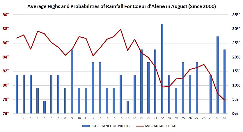
However, when the true averages are calculated for particular dates, there may be a few trends that can be seen. For example, I calculated the average temperature for Coeur d’Alene since Jan. 1, 2000. At Cliff’s station in northwestern Coeur d’Alene, his records began in late 2003, so I used other nearby stations to fill in the other years. Based on this data, the line in red on the chart shows that the average highs in our region are fairly warm during the first week of August. There is a slight dip around Aug. 8 and 12, but it peaks again around the Aug. 16. The data shows a steady decline after Aug. 16, but a slight rebound at the end of the month. Within the last 10 years, there have been many instances with at least several 90-degree days at the end of August.
The precipitation figures for the chart were calculated differently. Since 2000, the chart shows the percent of the number of days that measurable precipitation was received in Coeur d’Alene. For example, since 2000, there were only three out of 22 instances with measurable rainfall on Aug. 1 of each year, resulting in a percent probability of precipitation of 13% for that day.
The date with the most days of rainfall since 2000 was Aug. 22 with seven out of 22, resulting in a figure of 31.8%. The lowest percentage was on Aug. 28 with 0%. Since 2000, there has not been any measurable rainfall on that date, so if you’re planning outdoor activities on August 28, which is on a Sunday this year, your chances are pretty good that this particular day will be dry, based on climatology.
Of course, this kind of information is not an exact science, but it can show some overall temperature and precipitation trends since 2000 in Coeur d’Alene.
By the way, the day with the highest average temperature is July 31, with an average high of 90.1 degrees. A close second is July 28 with an average high of 89.5 degrees. By contrast, the coldest day, in terms of average highs, is on Dec. 31 with 30.6 degrees. January 1 has an average high since 2000 of 31 degrees. Dec. 31 also has the coldest average low temperature of 21.3 degrees in Coeur d’Alene.
According to the data, the wettest days since 2000 occurred on Nov. 9 and Dec. 13, 14 and 30 with measurable moisture reported 17 out of 22 days for each year, resulting in a 77.3 percent probability of precipitation on those dates. On Christmas day, the percent probability of precipitation is 63.6 percent since 2000.
In terms of our local weather, we’ve had a lot of summer heat over the last week across the Inland Northwest. Since July 23, Coeur d’Alene has reported high temperatures at or above the 90-degree mark. As of Sunday, we had four consecutive days with highs at or above 100 degrees, with the highest a sizzling 103 degrees on July 30. Cliff and I believe that we’ve likely seen the hottest period of the summer season. Temperatures later this week are expected to drop into the 80s and even into the upper 70s by Thursday. However, more hot weather is expected next week as the strong high-pressure system is expected to intensify over the region, so we may not be finished with the 100-degree days.
In terms of precipitation, we could see a few stray showers or a thunderstorm later this week and over the next several weeks, but conditions are still looking pretty dry through at least the middle of the month. By late August and into September, moisture totals should start to increase a bit across the region as the high starts to weaken. Assuming that ocean temperatures generally remain a little cooler than normal, the upcoming fall season should turn wetter than normal, especially in October and November. Stay tuned.
• • •
Contact Randy Mann at randy@longrangeweather.com.