For 'smart' forestry, try these apps


Over the last 10 years, the smartphone revolution has transformed the way forestry works. Now anyone with a smartphone or tablet has access to many of the same tools that professional foresters use. In this article, we’ll explore some of the apps that can help you interact with your land like a pro.
One of the biggest changes in forestry has been the introduction of Geographic Information Systems, or GIS. Similar to how Google Maps can show you all the roads in your neighborhood, a GIS system enables forest managers to map the boundaries of their forest stands and store information about the volume of timber on their property. Because everything is digital, it is also possible run analyses from the simple (like calculating the acreage of a stand) to the complex (like calculating the merchantable volume of timber in different product classes). GIS systems are also great for making maps.
Until recently, GIS systems were the exclusive purview of large industrial timberland owners and mills. However, the last several years have seen an explosion of free apps and software that empower private landowners to do the same type of mapping and analysis as the professionals. Most of the GIS-type work that you’ll want to do on your smartphone or tablet falls into two main categories: Mapping and Data Collection.
Mapping
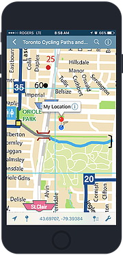
Over the last two years, Avenza Maps has emerged as the leading way for recreational users to use maps on their smartphones. It works on iOS, Android, and Microsoft mobile devices and is similar in many ways to Google Maps. The big difference is that you can load custom maps onto your phone. This is particularly useful if you have access to aerial imagery of your forest, georeferenced PDFs of your property, or other similar data. Avenza also has a “map store” with a variety of digital maps available for purchase, making it easy to get started.
Once you have your map loaded on your phone, you can use the app to create placemarks at various points of interest within your property. You could mark the location of particularly large trees or areas that have unique animal habitat. Avenza makes it easy to export these placemarks so that you can share them with your family and your forester.
Avenza Maps is currently free for personal use, although they charge an annual subscription fee for commercial use and some of the custom maps (including some from the US Forest Service) must be bought.
Data collection
Systematically measuring trees, often called “timber cruising,” is a whole specialty unto itself. If you’re looking to sell timber or develop a management plan for your forest, it’s usually best to obtain the services of a local forestry consultant. But it also doesn’t hurt to know how to “cruise” yourself and it can be a fun way to interact with your property.
The three major steps in a timber cruise are laying out a grid of sample plots across the property, measuring the trees in each plot, and then working up the summary report to see how much merchantable volume of each species there is on your land.
When it comes to deciding how dense of a grid of plots to sample on your property, it’s tough to give a general answer. Many cruisers in the Northwest put in a 10-factor prism plot every three to four acres, although this is just a rough rule of thumb. For higher value timber, the sampling intensity and plot type may vary. This is a place where expert judgement is very useful in tailoring the sampling strategy to your particular property.
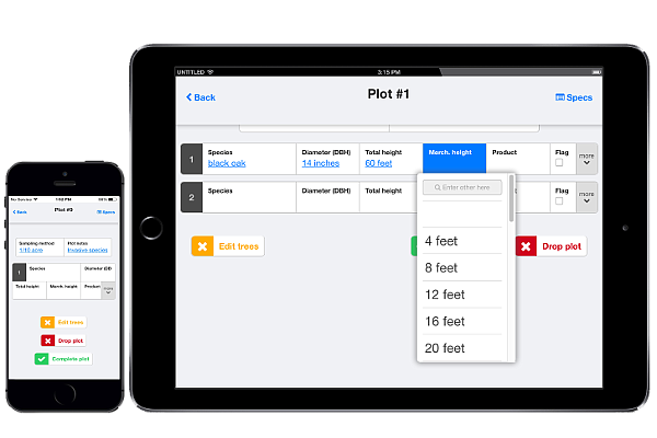
Once you have decided on a sampling strategy, there are several apps that make it easy to handle most of the cruising process. Plot Hound is a free app that runs on Android and iOS that will navigate you to each plot and serve as a convenient data entry notepad. Its free companion website called Canopy can automatically lay out a grid of plots and then work up all the statistics when you are done. I initially built Plot Hound for internal use at my company, SilviaTerra, but over the last eight years thousands of professional and hobbyist timber cruisers across the U.S. have used this free app to measure hundreds of thousands of acres.
Accessories
The beauty of a smartphone is that it packages so much complexity into a single, simple device. From a high-resolution touchscreen, camera, and long-lasting battery to cellular antennas, GPS, and a compass, modern smartphones are full of useful sensors and communications equipment. For most private landowners operating on holdings of around 50-100 acres, your smartphone will likely have everything you need to map and collect data on your property.
If you do want to take the next step in operational efficiency and precision, there are a few accessories to consider. The first is a battery extender. When you’re out in the woods for hours running the screen and the GPS on your phone, your battery can take a real hit. Luckily, there are a ton of options for battery extenders, from external power bricks to phone cases with extra batteries built in.
Speaking of cases, you might want to consider getting a rugged case for your phone just in case you drop it while you’re out in the woods. A screen protector to guard against scratches and reduce glare out in the sunlight isn’t a bad idea either.
The only other bit of extra hardware to consider is a Bluetooth GPS. While your phone’s internal GPS does a pretty good job, it can sometimes struggle underneath tree canopy and it doesn’t always get the greatest accuracy — usually 30 feet or so. If you want higher precision location measurements (say for mapping the boundary of your property), you can find external Bluetooth GPS units that have specialized antennas that get better signal and pick up additional GPS satellites. Both DualGPS and BadElf sell Bluetooth units that can get you to five to 10-foot accuracy. It’s possible to get survey-grade GPS units that get even better accuracy, but they’re so expensive that you may be better off calling your local surveyor!
And beyond!
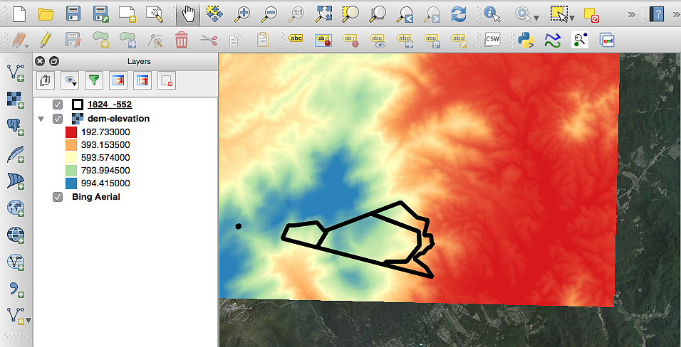
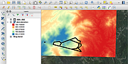
Once you’ve gotten the hang of the basics of mapping and data collection, you’re ready for the next steps. Unfortunately, it’s a bit outside the scope of this article to explore some of the more powerful aspects of GIS, but I can point you in the right direction. There is a very popular (and free!) desktop GIS system called “QGIS” that has many of the features of the expensive GIS systems used by professional foresters. YouTube has a ton of tutorial videos on how to use QGIS and the QGIS website has plenty of getting started guides too.
There is also a whole universe of freely available satellite and other remotely-sensed imagery for much of the U.S. Try Googling “Landsat” and “National Agricultural Imagery Program” for a start. Your tax dollars have paid for this imagery, so it’d be a shame not to use it on your own land!
I hope that this article has given you some ideas for using your smartphone to interact with your forest. There will certainly be more technological advances in the coming years, so stay tuned for an update.
Max Nova is a Yale University graduate and founder of SilviaTerra. Using satellites, cloud computing, and mobile technology, SilviaTerra has inventoried millions of acres of forest and helps the top U.S. timber companies use data to achieve forest management objectives.