
Slideoff central
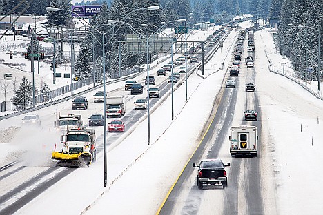
<p>Traffic in both eastbound and westbound lanes were backed up due to multiple vehicle slides offs along Interstate-90 Monday between Coeur d’Alene and Post Falls.</p>
The ice was not so nice to motorists on Monday.
Slick roads resulted in 18 crashes and 20 slideoffs reported to the Kootenai County 911 system as of 3:30 p.m., said Kootenai County Sheriff's Office Lt. Stu Miller.
"Heavy snow in a short amount of time coupled with people not driving for the conditions present are a primary reason for the high number of slideoffs and crashes," Miller said. "Deputies and troopers are dealing with several slideoffs that haven't been called in as well."
Several of the crashes and slideoffs occurred in both directions on Interstate 90 between Post Falls and Coeur d'Alene, causing traffic delays.
Teresa Baker, Idaho State Police spokeswoman, said ISP responded to 11 crashes (all non-injury) and 47 slideoffs in the five northern counties from 8:30 a.m. to 4:30 p.m.
Miller said none of the reported crashes in Kootenai County as of mid-afternoon resulted in serious injuries.
An accident in Post Falls knocked over a power pole, according to Post Falls Police. Coeur d'Alene Police responded to five accidents and a slideoff between 5 a.m. and 5 p.m.
The treacherous roads prompted some school districts in the region, including the Plummer-Worley School District, to release students early on Monday. Some sporting events were postponed.
Freezing temperatures are expected to give way to a gradual thaw starting today through Friday.
A rain and snow mix is expected for the rest of the week, with high temperatures reaching the upper 30s and lower 40s, according to Meteorologist Randy Mann.
The National Weather Service issued a flood watch Monday for Benewah and Kootenai counties from tonight through Friday night. A watch means that flooding is possible but not imminent.
"Two separate storm systems will bring warmer temperatures and rain to the lower elevations over the next several days, bringing with them the possibility for minor flooding," according to the NWS. "The ground is still frozen in much of the region, which will increase the amount of runoff from the rainfall and snowmelt."
The NWS said possible impacts include ponds that form in areas with poor infiltration due to the frozen ground, overflows at culverts and storm drains plugged with ice and snow, rising creeks and roadside ditches running full.